


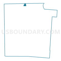
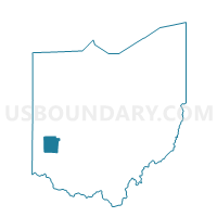
PRECINCT UNION-C, Montgomery County, Ohio
About
Outline

Summary
| Unique Area Identifier | 650303 |
| Name | PRECINCT UNION-C |
| County | Montgomery County |
| State | Ohio |
| Area (square miles) | 0.73 |
| Land Area (square miles) | 0.73 |
| Water Area (square miles) | 0.00 |
| % of Land Area | 100.00 |
| % of Water Area | 0.00 |
| Latitude of the Internal Point | 39.91194260 |
| Longtitude of the Internal Point | -84.31480490 |
Maps

Graphs
Select a template below for downloading or customizing gragh for PRECINCT UNION-C, Montgomery County, Ohio


Neighbors
Neighoring Voting District (by Name) Neighboring Voting District on the Map
- PRECINCT CLAYTON 1-A, Montgomery County, OH
- PRECINCT UNION SOUTH CENTRAL, Miami County, OH
- PRECINCT UNION-A, Montgomery County, OH
- PRECINCT UNION-E, Montgomery County, OH
- PRECINCT UNION-F, Montgomery County, OH
Top 10 Neighboring County Subdivision (by Population) Neighboring County Subdivision on the Map
- Clayton city, Montgomery County, OH (13,209)
- Union township, Miami County, OH (9,871)
- Union City township, Montgomery County, OH (6,369)
- Union city, Miami County, OH (24)
Top 10 Neighboring Place (by Population) Neighboring Place on the Map
Top 10 Neighboring Unified School District (by Population) Neighboring Unified School District on the Map
- Northmont City School District, OH (34,523)
- Milton-Union Exempted Village School District, OH (9,733)